
Superstorm Sandy Devastates East Coast
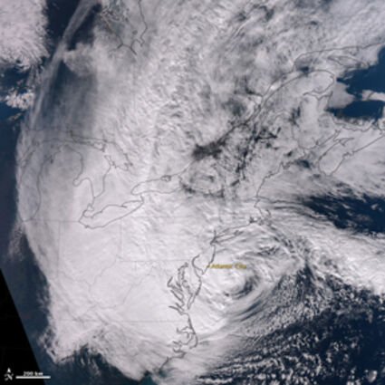
On October 29, 2012, Hurricane Sandy approached the densely populated U.S. East Coast. An estimated 60 million Americans were expected to be affected by rain, wind, snow, or ocean storm surges from the storm. The Visible Infrared Imaging Radiometer Suite (VIIRS) on the Suomi NPP satellite acquired this natural-color image of the storm at 1:35 p.m. Eastern Daylight Time (17:35 Universal Time) on October 29. NASA photo.
Almost every school in the North Country let their kids out early on Monday with a few schools delaying on Tuesday morning. Just about every event in the North Country was also canceled Monday night. A high wind warning was issued from Monday Octo...
For access to this article please
sign in or
subscribe.


Reader Comments(0)